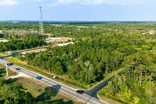
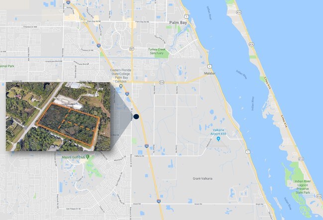
Property Record
1909 Unknown, Malabar, FL 32950

NEARBY LISTINGS FOR SALE OR LEASE
Property Detail
1909 Unknown
Palm Bay-Melbourne-Titusville, FL
Florida Indian River Land Co
29-37-10-00-00299.0-0000.00
E 1/2 OF S 200 FT OF LOT 24 OF PB 1 PG 165 EX S 35 FT & E 25 FT AS DES IN ORB 2248 PG 575
Commercialacreage
Brevard
A
Florida
12009C0680G
24
2024
1.16 AC
2025
Brevard County
0652311034
Orlando
DEMOGRAPHICS near 1909 Unknown
1 Mile
3 Mile
5 Mile
2024 Total Population
2,916
42,518
116,457
2029 Population
3,255
46,889
128,505
Pop Growth 2024-2029
+ 11.63%
+ 10.28%
+ 10.35%
Average Age
40
43
42
2024 Total Households
1,104
16,141
45,819
HH Growth 2024-2029
+ 11.32%
+ 10.06%
+ 10.13%
Median Household Inc
$57,628
$53,630
$56,613
Avg Household Size
2.60
2.60
2.50
2024 Avg HH Vehicles
2.00
2.00
2.00
Median Home Value
$239,743
$219,074
$222,481
Median Year Built
1993
1990
1993
Nearby Places
Map Layers
Map Styles
 Street
 Aerial
- Restaurants
- Banks
- Shops
- Fitness
- Groceries
PUBLIC TRANSPORTATION
AIRPORT
Melbourne Orlando International
DRIVE
WALK
Distance
Melbourne Orlando International
22 min
10.1 mi
Freight Ports
Port Canaveral
DRIVE
WALK
Distance
Port Canaveral
54 min
43.9 mi
SALE & LEASE HISTORY
LISTING DATE
SALE/LEASE

Sep 24, 2019
For Sale
Mar 27, 2025
For Sale
Dec 18, 2018
For Sale
Nearby Properties
Address
Land Use
TOTAL SIZE
Lot Size
Zoning
Address
Land Use
TOTAL SIZE
Lot Size
Zoning
282,680 SF
16 AC
IU
Address
Land Use
TOTAL SIZE
Lot Size
Zoning
294,170 SF
70.66 AC
IU
Address
Land Use
TOTAL SIZE
Lot Size
Zoning
307,849 SF
39.14 AC
IU
Address
Land Use
TOTAL SIZE
Lot Size
Zoning
257,044 SF
14.99 AC
Address
Land Use
TOTAL SIZE
Lot Size
Zoning
260,331 SF
9.90 AC
RM10
Address
Land Use
TOTAL SIZE
Lot Size
Zoning
267,548 SF
23.10 AC
RM10
Address
Land Use
TOTAL SIZE
Lot Size
Zoning
121,353 SF
24.37 AC
RS2
Address
Land Use
TOTAL SIZE
Lot Size
Zoning
143,529 SF
7.76 AC
RM20
Address
Land Use
TOTAL SIZE
Lot Size
Zoning
216,692 SF
28.97 AC
CC
Address
Land Use
TOTAL SIZE
Lot Size
Zoning
104,620 SF
12.82 AC
IU
Address
Land Use
TOTAL SIZE
Lot Size
Zoning
103,507 SF
24.90 AC
IU
Address
Land Use
TOTAL SIZE
Lot Size
Zoning
222,925 SF
12.75 AC
PUD
Address
Land Use
TOTAL SIZE
Lot Size
Zoning
69,508 SF
12.66 AC
PUD
Address
Land Use
TOTAL SIZE
Lot Size
Zoning
48,492 SF
17.45 AC
OI
Address
Land Use
TOTAL SIZE
Lot Size
Zoning
150,810 SF
15.11 AC
CC
Address
Land Use
TOTAL SIZE
Lot Size
Zoning
79,677 SF
13.90 AC
IU
Address
Land Use
TOTAL SIZE
Lot Size
Zoning
108,024 SF
15.15 AC
CC
Address
Land Use
TOTAL SIZE
Lot Size
Zoning
171,010 SF
16.35 AC
CC
Address
Land Use
TOTAL SIZE
Lot Size
Zoning
75,599 SF
11.06 AC
PUD
Address
Land Use
TOTAL SIZE
Lot Size
Zoning
108,360 SF
18.48 AC
CC
Address
Land Use
TOTAL SIZE
Lot Size
Zoning
36,771 SF
16.99 AC
IL
Address
Land Use
TOTAL SIZE
Lot Size
Zoning
86,067 SF
13.20 AC
CC
Address
Land Use
TOTAL SIZE
Lot Size
Zoning
49,541 SF
6.94 AC
NC
Address
Land Use
TOTAL SIZE
Lot Size
Zoning
88,978 SF
4.51 AC
PUD
Address
Land Use
TOTAL SIZE
Lot Size
Zoning
59,871 SF
6.56 AC
LI
Address
Land Use
TOTAL SIZE
Lot Size
Zoning
55,111 SF
11.55 AC
CC
Address
Land Use
TOTAL SIZE
Lot Size
Zoning
64,984 SF
7.20 AC
RM15
Address
Land Use
TOTAL SIZE
Lot Size
Zoning
54,774 SF
2.67 AC
CC
Address
Land Use
TOTAL SIZE
Lot Size
Zoning
44,508 SF
4.81 AC
RM20
Address
Land Use
TOTAL SIZE
Lot Size
Zoning
101,670 SF
8.30 AC
LI
The World's #1 Commercial Real Estate Marketplace
Connect with us
© 2026 CoStar Group
The information above has been obtained from sources believed reliable. While we do not doubt its accuracy we have not verified it and make no guarantee, warranty or representation about it. It is your responsibility to independently confirm its accuracy and completeness. Any projections, opinions, assumptions, or estimates used are for example only and do not represent the current or future performance of the property. The value of this transaction to you depends on tax and other factors which should be evaluated by your tax, financial, and legal advisors. You and your advisors should conduct a careful, independent investigation of the property to determine to your satisfaction the suitability of the property for your needs.